
Description
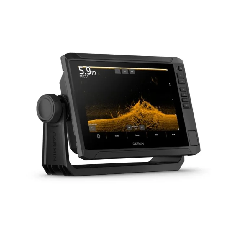
They say the local fishermen know their area better. Well, not anymore. With the Garmin Echomap UHD2 Chartplotters with the built-in Garmin Navionics+ mapping you can see clear, sharp fish arches with the Garmin traditional sonar. Use ClearVü scanning sonar featuring vivid color palettes for clear, high-contrast views below your boat. With the Echomap UHD2 92SV Chartplotter, which offers Garmins best-in-class sonar and mapping and premium touchscreen display with keyed-assist, youll know the water even better than they do.
The bright 9 touchscreen display with keyed-assist is user-friendly and easy to read.
Good things come in threes. Three sonar types, that is: Garmin traditional, ClearVü and SideVü sonars. Want improved detail? Check. Distinguished targets? Thats the beauty of high-contrast vivid color palettes.
With crisp, clear traditional sonar and brilliant ClearVü and SideVü scanning sonars, the fish will have nowhere to hide. The Garmin Echomap UHD2 also supports LiveScope live-scanning sonar.
Built-In Sonar: Use the included GT51M transducer to get Garmin Chirp traditional sonar plus Chirp ClearVü and Chirp SideVü scanning sonars.
High-contrast vivid scanning sonar color palettes make it easier than ever to distinguish targets and structure.
The Echomap UHD2 device supports a variety of Garmin transducers. The 9 chartplotter comes with a GT56 transducer.
High Sensitivity GPS: Plan and create routes and view your boats speed on your fishfinder using high-sensitivity GPS.
Wireless Networking: If you have another compatible Echomap UHD2 Chartplotter on your boat, the 5 and 7 models can wirelessly share information such as sonar, waypoints and routes with them.
Built-in Wi-Fi Connectivity: Connect to the ActiveCaptain® mobile app to transfer waypoints, receive smart notifications and access the Garmin Quickdraw Community.
Chartplotters with built-in Garmin Navionics+ charts include downloadable Auto Guidance+ technology3 with the ActiveCaptain app.
The Echomap UHD2 wirelessly connects to your Force trolling motor to create and follow routes, navigate to waypoints, control speed, check battery life and more.
By networking select Garmin chartplotters with a Force® trolling motor and your compatible Power-Pole shallow water anchoring system, you can access advanced boat control features4 from your plotter, including smart anchor auto-deployment, smart anchor jog, auto stow, anchor drag detection and auto guidance5 end-of-route anchoring. Spend more time fishing, less time positioning.
|
Traditional Sonar Using powerful sound waves to ping objects in the water below, Traditional Sonar translates the echoes from those waves, into the images of fish, structure and bottom depths, you see on your display. This type of pulse, or signal may be high in power, but its short in duration. This limits the total amount of energy that can be transmitted into the water column below. The cone-shaped beam, of the typical sonar transducer, is approximately 40° degrees, or less. However, this signal expands the farther it travels in the water column, so the cone of coverage it produces on the bottom of a lake can be quite large. Different frequencies reveal different levels of detail. For example, higher-frequency sonar is best at providing clear views of fish and structure in shallower water situations. Conversely, a low-frequency pulse can penetrate deep water but provides less imaging detail. To provide a more balanced combination of depth and detail, most traditional sonars now use a dual-frequency transducer for coverage thats easier to translate. |
Scanning Sonar
Scanning sonar technology, uses high-frequency pulses, to give you a detailed, photo-real representation of fish and structure in the water below. Instead of a cone-shaped beam, Garmin scanning sonars use a narrow beam of very high-frequency energy, to create extremely detailed, digitally composed sonar images.
Garmin chartplotters and transducers are available with two main types of imaging: ClearVü and SideVü scanning sonars. The difference between the two is that ClearVü is down-imaging sonar, designed to show a high level of detail in a narrow window under the boat, while SideVü, as the name implies, is side-imaging sonar covering larger areas of water, to either side of your boat. Thus, ClearVü generates detailed images of what is below the boat, while SideVü covers a larger viewing area around your boat. Its useful for identifying bottom features, structure and cover where the best fishing spots may be found.
Included:
ECHOMAP UHD2
GT56-TM transducer
Power cable
Tilt mount with quick release cradle
Protective Cover
Hardware
Documentation
Download here the Owners Manual.
Download here the Installation Instructions.
Technical Characteristics
Part Number: 010-02687-GN
Dimensions: 10.4″ x 6.5″ x 3.2″
Weight: 1.3 kg / 2.9 Lbs
Touchscreen with Keyed Assist
Water Rating: IPX7
Display Type: WVGA Color
Display Size: 7.8″ x 4.5″, 9.0″
Display Resolution: 1024 x 600 pixels
Mounting Options: Bail or Flush
Accepts Data Cards: 1 x MicroSD Card
Waypoints / Favorite Locations: 5000
Track Points: 50,000
Tracks: 50
Navigation Routes: 100
With GPS, Glonass, Galileo, Beidou
With built in Receiver 10Hz
Supports Multi Band, Multi Constellation GPS
Power Input: 9 to 18 VDC
Current Draw at 12VDC: 1.72 A
Max Current Draw at 12VDC: 3.5 A
Power Consumption at 10VDC: 20.7W
Built-in Dual Frequency Sonar
Power Output: 500W
Traditional Sonar Frequence: Built in Single Channel 50/77/83/200 kHz L, M, H CHIRP
ClearVü: Built in 260/455/800/1000/1200 kHz
SideVü: Built in 260/455/800/1000/1200 kHz
Panoptix Sonar
Livescope
12-Pin Transducer Ports
Garmin Marine Network Ports
NMEA 2000 Ports
Garmin Wi-Fi Network
Reviews
There are no reviews yet.